CLIM 04: Landscape Evidence of Glaciation #
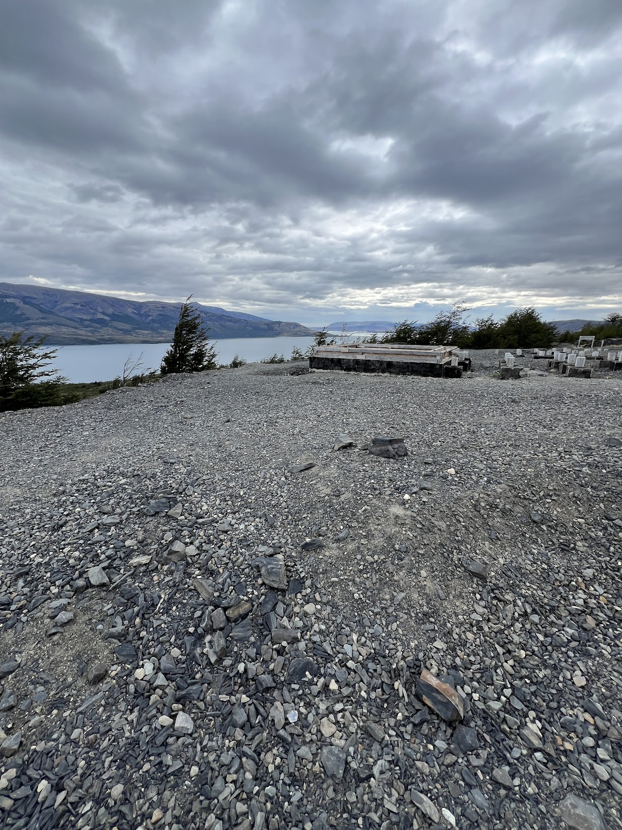
Our field expedition began at Mirador Grey, where CLIM 04 took place. The viewpoint overlooks Lago de Toro, which is a glacial lake formed after the last glacial maximum - within the last 10,000 years.
The fundamental question of this class was: How can we tell if a lake was formed by glaciation? What evidence can support that hypothesis?
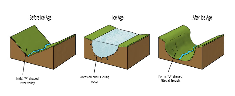
The first piece of evidence that points to previous glaciation is the valleys. The lake is surrounded by U-shaped valleys, which are a key sign of previous glaciation - sharper, V-shaped valleys tend to form from water instead. From the viewpoint, there was also a visible glacial tongue that made it easier to understand how the U-shaped valley is formed by the glacier - water doesn’t drag against the rock like the glacier does, so its erosion footprint is different.
The next feature was the scarring on exposed rock. Since the glacier is dragging against the rock, larger rocks picked up by the glacier that are close to the edge will scrape against the sides of of the rock. This creates really distinct striation patterns that allowed us to tell in which directions the glacier receeded/advanced.
In terms of larger examples, the biggest piece of evidence we looked at were moraines. There are two major types of moraines, lateral and terminal. all of the sediment hills surrounding the lake are likely moraines, as the glacier is pushing the sediment and rock it collects as it moves, and it is deposited along the sides of the glacier. However, a terminal moraine, while still made up of collected rock and sediment, forms at the farthest travelled point of the glacier.
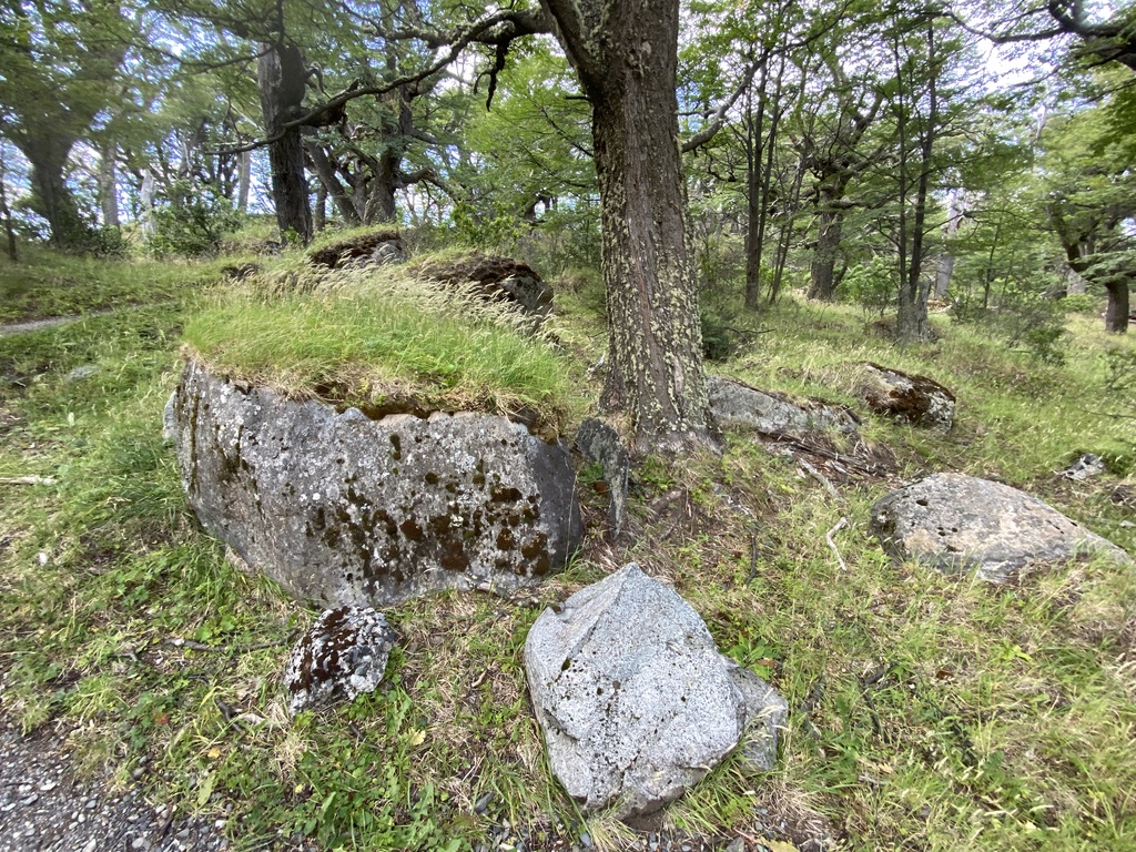
While glaciers largely collect sediment and rocks, occasionally they will collect large rocks/boulders and deposit them with the moraines. These are called erratic rocks, and can be seen on/in moraines. We certainly saw a few during our hike! They can be a reasonable size, or significantly large, as seen in the image below from one of the moraines we went on later in the field expedition.
Paleo-shorelines were also able to be seen. Around the lake, there are flat areas with small debris like sand or rock that could have potentially been old shoreline from when the lake was in a different place.
In conclusion, our first class gave us the knowledge to identify lakes formed by glaciers, similar to Lago de Toro. These landmarks are active indicators of a changing climate, since glaciers are directly tied to climactic conditions, and they leave very permanant marks on the surrounding geological environment.
CONS 05: Patagonian Conservation Model #
In CONS 05, we went over the Patagonian/Chilean conservation model. In Chile, 33 percent of protection is marine, 21 percent is social/cultural protection, 24 percent is terrestrial, and 15 percent is freshwater conservation. The large governmental organization that manages Chilean protected land is the National Forest Corporation (CONAF). While CONAF is state-owned, it is not a public agency. This means that it is structured like a private corporation. However, recently, the newly established National Service of Biodiversity and Protected Areas (SBAP) is poised to take on some of CONAF responsibilites, and this is a public service. This is good because CONAF was not really set up with the intention of managing these large tourist-based sites.
Beginning with a specific example of Torres del Paine, UNESCO designated TdP as a Biosphere Reserve in 1978. This status is given to regions that have high ecological importance and require a balance between conservation and human activity.
Biospheres follow a zoned structure:
- Core zone: This is the most strictly protected area. It is meant to preserve biodiversity and natural ecosystems as the top priority. This is also the most regulated in terms of human activity - no permanant infrastructure, and as little human impact as possible.
- Buffer zone: Around the core zone, the buffer allows for more human activity with larger footprints. This could be guided tours, highly trafficked sections of parks, trail networks, etc. However, there is still an effort to minimize human impact, especially preventing it from reaching the core zone as much as possible.
- Transition zone: The outermost area is the transition zone, which surrounds the buffer zone. This is where higher impact activities take place and permanant infrastructure is present. This could be anything from ranches (estancias) to towns serving the tourism activity. This is also the areas where community outreach about conservation really occur, and I’d argue its the most important zone!
Torres del Paine is certainly one of the more highlighted areas of Chile when it comes to conservation, but there is an important difference between public and private conservation in the surrounding biosphere. In the core, public entities engage in passive conservation, where it is about minimizing impact and leaving things as they are. However, in the buffer and transition zones, which are often still protected ecosystems but might be privately owned, there is a stronger emphasis on active conservation. This involves intervening to create a more ideal ecosystem, and one example we saw of this was at an estancia that is using eco-tourism to take down large amounts of fencing to help encourage better animal movement.
Chile’s conservation model demonstrates a pretty different style than what is utilized in the United States. Lots of important conservation work outside of protected areas relies on NGOs and private interest. CONAF, while not ineffective, suffers from problems due to its original organizational structure and scope, which makes the introduction of SBAP more promising, as it is tailored to be more in line with Chile’s conservation needs, especially in the face of biodiversity loss and climate change.
ECO 04: Ecological Succession and Ecology of Lichens in Rocks #
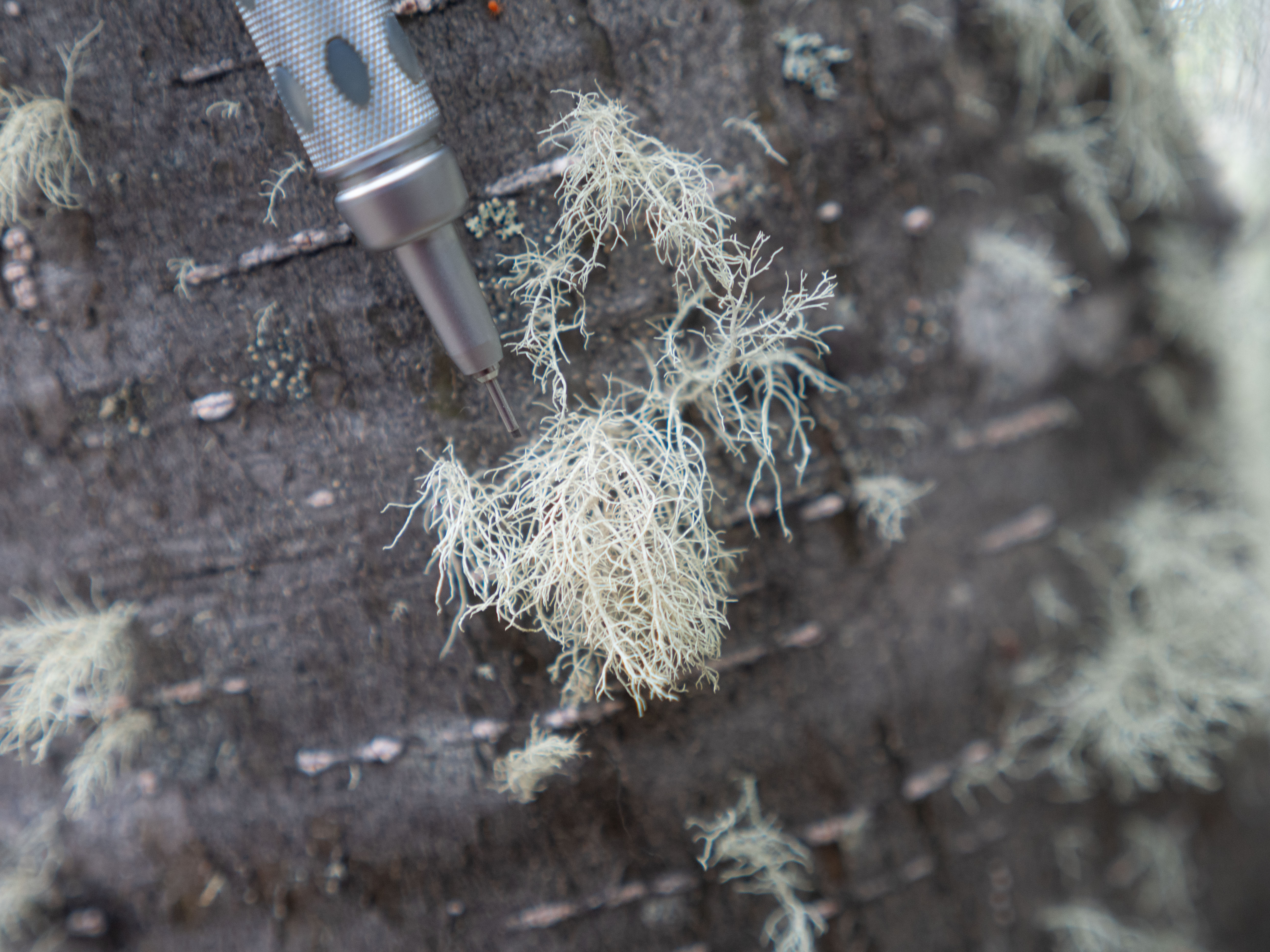
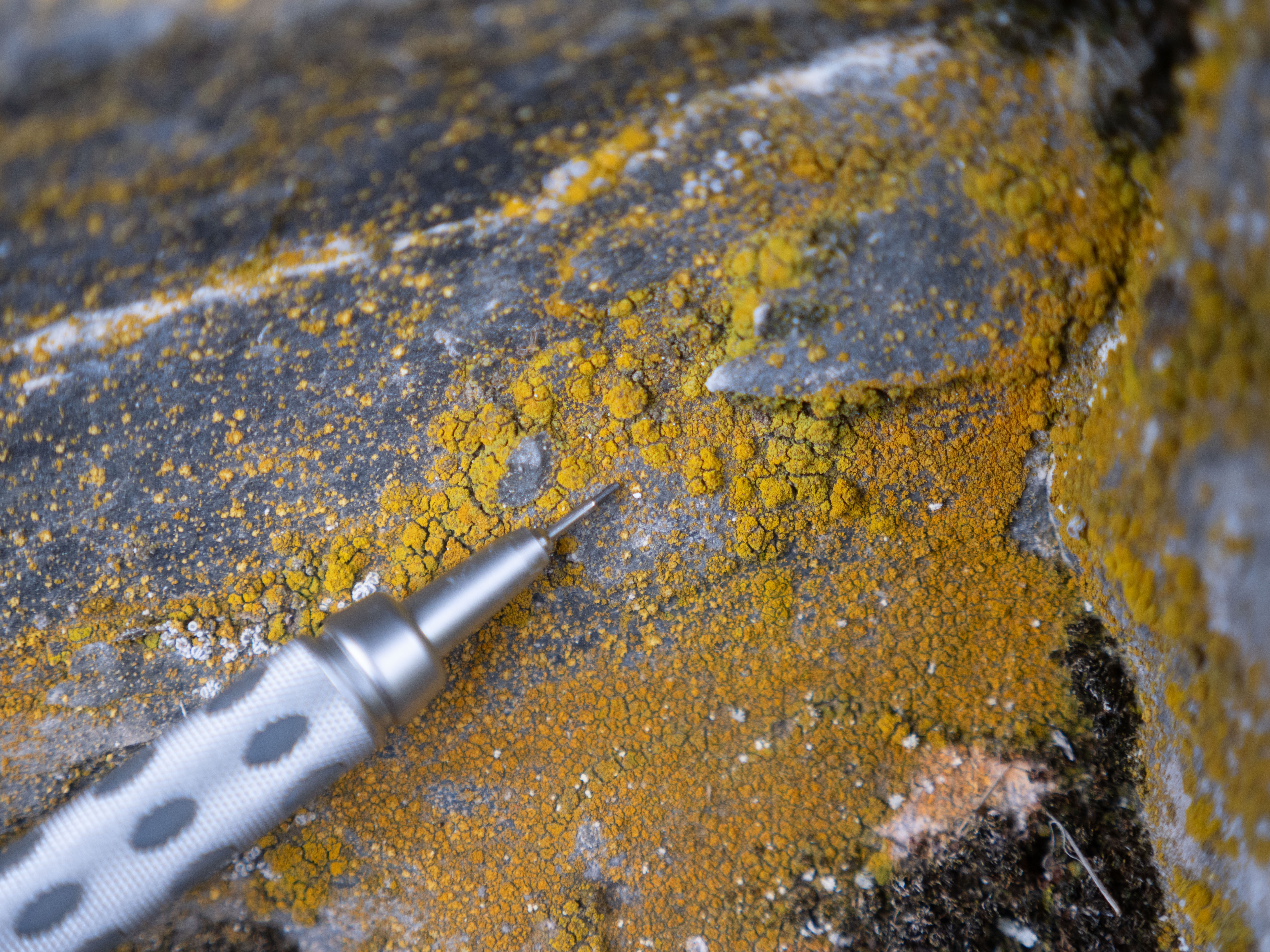
For our Patagonian ecology class, we stopped during our long day hike to learn about lichens. Lichens are resilient organisms formed by a symbiotic relationship between algae (photobiont) and fungi (mycobiont). The fungal component provides structure, protection, and attachment to surfaces like rocks or a tree, while the photobiont does photosynthesis, producing nutrients to sustain the relationship. This relationship is what makes lichen a pioneer species - they can essentially colonize and begin to create an ecosystem from an entirely barren landscape.
In our specific exercise, we focused on identifying lichens across different substrates and morphological types. Beginning with the morphological types:
- Crustos lichens are really thin, almost one with the substrate. They kind of just look like paint, with no clear structure.
- Foliose lichens have clear leaf-like structures that are not firmly attached to the surface, and look more like plants.
- Fruticose lichens grow more out, and sort of look like shrubs/strings. They are attached to the rock at a small point and just trail out.
Each morphological type was present in the field, but we saw mostly crustos and fruticose, since old mans beard lichen (fruticose) and various crustos lichens were present on the rocks and trees. Speaking of substrates, there are fancy names to define each one:
- Saxicolous lichens grow on rocks, and are the absolute pioneer most of the time.
- Corticolous lichens are on living tree bark, and are very good indicators of air quality/forest health. The beard lichens are corticolous.
- Terricolous lichens are on soil, moss, or other general organics - we saw a few of these growing on moss.
Getting a chance to look closely at lichens was honestly eye-opening. They’re easy to miss, but once you know what to look for, you start noticing them everywhere, especially when I’m climbing on rock. Beyond that, it’s cool to realize how much they contribute to the ecosystem, even though they’re not flashy or obvious. Definitely walked away with a better appreciation for how important they are and how much is going on right under my nose.